EO AFRICA R&D Facility Online Course
Surface Flood Modelling Supported by Cloud-Based RS & GIS
Introduction to the course
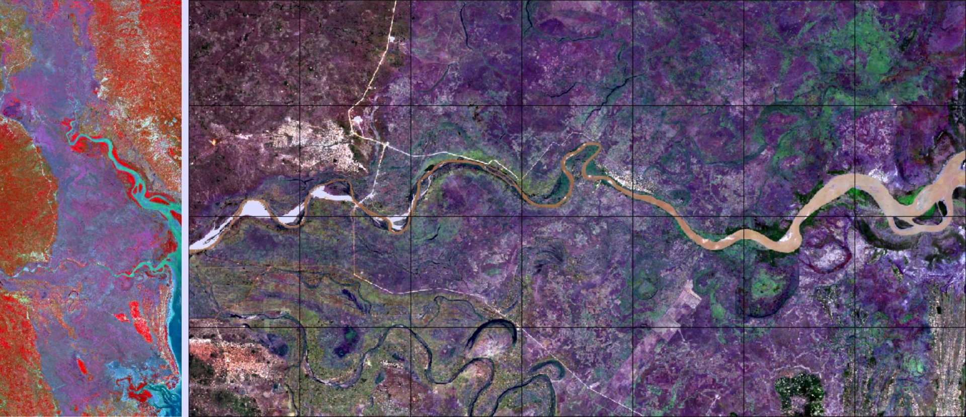
The ever-increasing spatial resolution offered by the newest generation of satellite sensors allow us to monitor surface water at pixel level. Use of radar allows mapping under cloud cover conditions. Optical imagery supports a more natural identification of water bodies and digital elevation models add to the identification of potential flood areas. This course reviews all these concepts using a variety of different publicly and freely available data sets and adds a foundational but complete layer on surface water modelling using a full 2D version of HECRAS free software.
This course will provide/present participants with:
- The most relevant data sources related to surface water detection and modelling, including satellite derived precipitation, land cover classification and soils data retrievals.
- Guide on optical (S2) and radar (S1) imagery identification of surface water.
- Overview of highly relevant sites for water risk analysis, using a global surface water database.
- Hydroprocessing of a DEM for basin, subbasin, and hydrologic circuit delineation.
- Forcing and land properties data retrieval and processing for flood modelling.
- An introduction to hydrology and hydraulic glossary in modelling.
- A guided local flood inundation case study using HECRAS.
Mode of Delivery
The course consists of videos, PowerPoints, quizzes, and practical exercises, supplemented by reading material and reference materials. All materials will be offered through the Moodle Cloud learning platform. Participants are expected to digest the training materials independently by themselves (i.e., no live teaching is foreseen). Interaction with the teaching staff will be possible through a series of dedicated live feedback sessions (hosted through Zoom) and a Q&A forum.
Prerequisites
The participants are expected to have a basic knowledge on Earth Observation, basics on Python programming and the use of cloud environments for EO image processing for the generic part of the course. For the second part it will be an advantage for those professionals with a hydrological background. The guiding videos are expected to serve as foundational tutorials for professional of other sciences allowing them to cover the same concepts. In this case, some more dedicated time is expected.
Part of this pre-knowledge can be acquired by attending the first two online courses of the EOAfrica series (OC 1: Cloud Computing and Algorithms for EO Analyses; OC 2: Principles of and advances in Earth Observation). Access to both courses will be given to those selected to attend this online course. Although having participated in that course is certainly an advantage, candidates are not expected to have attended this course.
Selection
The course will be offered to a maximum of 65 participants. Selection will be based on relevant academic background and employment. Only applicants working for an African-based organization are eligible. We will strive to have a gender-balanced and country-balanced group of participants. Preference is given to candidates working as (Ph.D.-) researchers, post-doc, and university staff. Selection will be made two weeks before the course starts to provide early access to prerequisite online courses on Cloud computing and EO.
Timeline
The course will span over 4 weeks with a daily study-load of 2 hours – 10 hours a week.
Registration:
Instructors:
-
Assistant Professor / Project Manager – Department of Water Resources, Faculty ITC of the University of Twente
https://people.utwente.nl/b.h.p.maathuis
b.h.p.maathuis@utwente.nl -
Senior lecturer – Department of Water Resources, Faculty ITC of the University of Twente
https://research.utwente.nl/en/persons/gn-parodi
g.n.parodi@utwente.nl