Following the successful 2022-2023 call for research proposals, the EO AFRICA R&D Facility, in coordination with the European Space Agency (ESA) and the African Union Commission (AUC), launched in September 2022 a 2nd call for proposals. The aim of this call is to extend the support to African-European collaborative research efforts in the domain of EO applications. Similar to the 1st call, applicants were invited to submit their research ideas to create EO-based algorithms and workflows by leveraging cutting-edge cloud-based data access and computing infrastructure to tackle water scarcity and food security challenges in Africa.
This grant provides the selected proposals with 25,000 EUR for research activities during a period of 12 months. In addition, awarded projects will get free access to cloud-based Virtual Research Environments through the Innovation Lab of the Facility, dedicated user and technical support, access to EO AFRICA Space Academy events, and integration into the EO AFRICA Network for international scientific collaboration.
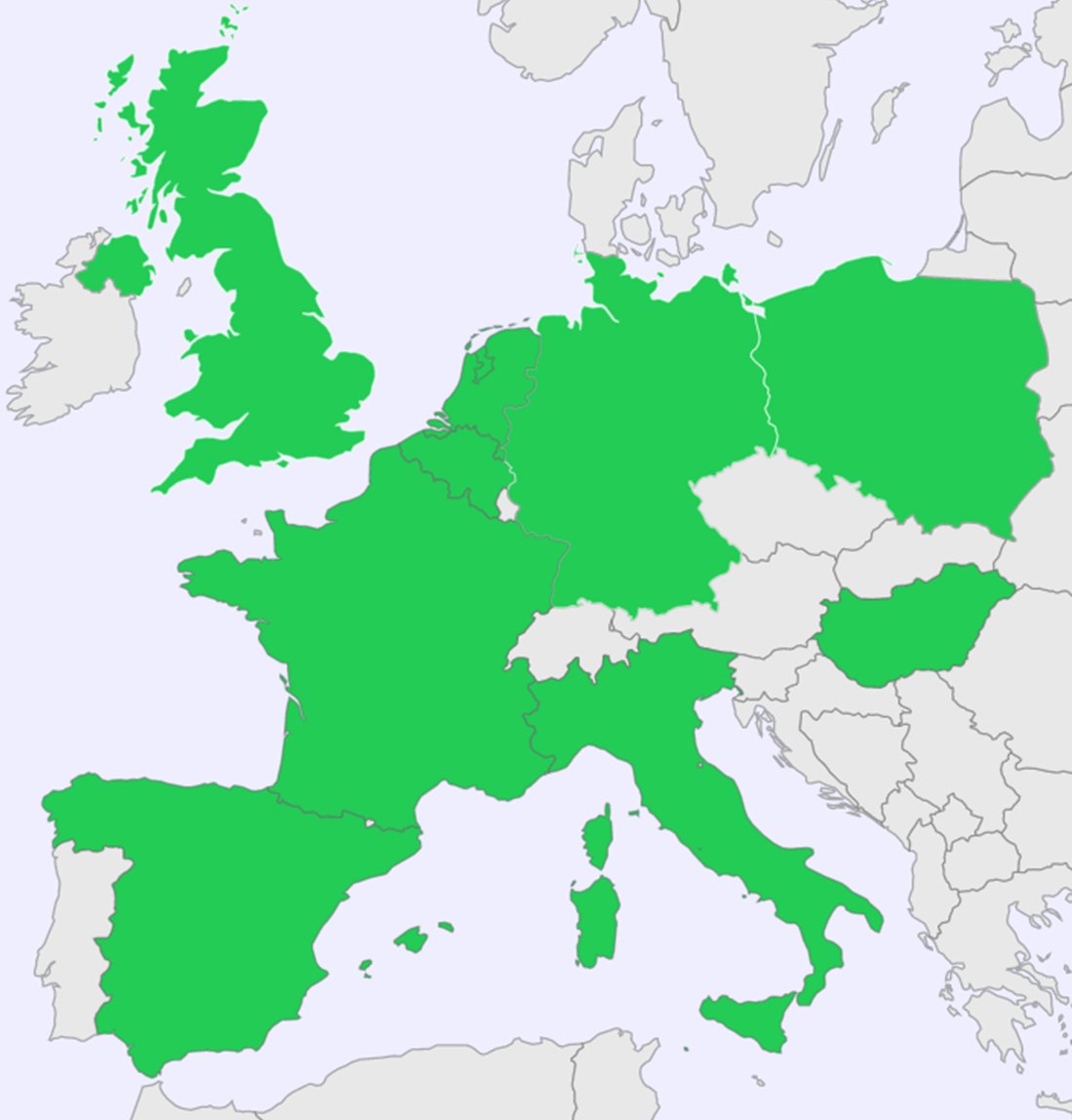
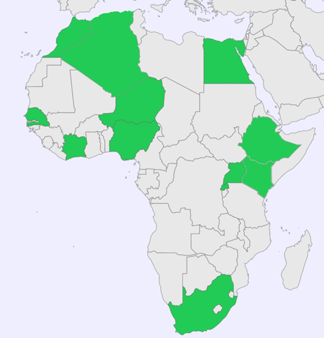
Following the evaluation of the proposals by the Selection Committee in collaboration with ESA and AUC, 17 research projects (listed below) were awarded for funding from 11 African and 9 European countries.
Funded Projects:
1BIG data archetypes for crops from EO
As population increases, so does the demand for food and food security. Field crops supply a large proportion of this globally, but pressures on crop area and productivity continue to grow. Earth Observation (EO) already provides much information, and new datasets offer more quality and detail for crop development and yield prediction at the field-scale and beyond. We use algorithms to interpret the data, but they are a complex response to a large number of soil, crop, and atmospheric conditions that must be disentangled to get at the crop information. We will test a new technique to map crop condition from EO for winter wheat in South Africa. We use physics models of the EO to describe their response to biophysical parameters, then machine learning to calculate the parameters from the measurements. But many parameters are uncertain when estimated like this. We use big data analysis globally to build typical models of the parameters that we call archetypes. We use these to provide robust estimates of all parameters for the entire growth cycle. But this science needs testing and application to areas of need, which is what we will do here in a collaboration between UK and South African scientists.
2Advances in deep learning model for irrigated agricultural area mapping: the case of Upper Awash Basin, Ethiopia Download
highlights
Well-managed irrigation farming has taken as the key strategic direction for achieving the food security scheme of Ethiopia. The irrigated farming area has increased in Ethiopia; however, its extent is rarely available and varies from source to source in Ethiopia. Although accurate irrigated farm area information is an indispensable input for decision-makers, it can be argued that the irrigated farming areas are not accurately known and precisely mapped. Therefore, the objective of this project is to develop an enhanced deep learning model using optical/SAR EO data and ResUNet model; for wheat crop irrigated farming area mapping. We will use S1/2, ICEYE and Planet time series complemented with in-situ and ancillary datasets for this analysis. Consequently, we will evaluate the developed data fusion algorithm and deep learning model as well as the resulting wheat irrigation maps using a highly accurate spatially explicit ground truth dataset using AOI-scale surveys of irrigation extent. The project output will contribute a lot for realising the application of EO data and deep learning model for the next 10 years Ethiopia’s agricultural perspective development plan (Goal 1), as well as “Agenda 2063 the Africa We Want” (Goals 1, 2 & 5) and the UN’s SDGs 1, 2 & 17).
3Fodder quality assessment in Senegalese rangelands based on Sentinel-2 images
Rangelands are the main source of fodder for animal feed in Sahelian pastoral systems. To ensure the sustainability of fodder resources and the resilience of pastoral populations to the impacts of climate change, timely assessment of fodder availability is essential. Operational tools for the evaluation, in particular by satellite remote sensing, of the fodder quantity have been developed for the natural rangelands of Senegal, but the question of the evaluation of the nutritional value of the pastures remains unanswered. Thus, the objective of the FATIMA project is to develop models for evaluating forage quality during the dry season by combining Sentinel-2 (S2) type images with field data analyzed by Near Infra-Red Spectroscopy. (SPIR) via statistical modeling techniques. The innovation concerns the integration of S2 images with NIRS data for the large-scale assessment of forage quality in the Sahelian zone. The models developed will complete the operational system of the Ecological Monitoring Center (CSE) for monitoring Senegalese routes. This system will thus contribute more effectively to the national framework for the management of natural rangelands for productive and sustainable pastoral farming, in the current context of global change.
4Leveraging inland radar altimetry over rivers with low cost GNSS reflectometry
Rivers fulfil a vital role in many countries by providing as a water resource, fishery ground, and as means of transport. At the same time, rivers can also pose hazards due to flooding and contamination. Managing a river’s resource poses significant challenges among stakeholders, especially for river systems such as the Nile, which crosses national boundaries. Modern earth observation missions such as Sentinel-3 and Sentinel-6 could potentially gauge many remote river locations and provide important observations to hydrological forecasts systems, but this currently still requires expert knowledge on processing algorithms and ground truth data. The overall goal of this project is to lower the barrier for (African) stakeholders to make use of satellite products for river altimetry and enable a low-cost and scalable solution for cross-validating observed river stages. To achieve this goal, our approach encompasses two components. The first one is the development of an open-source python module capable of ingesting and selecting satellite radar altimetry data. The second component involves the building and deployment of several low-cost GNSS-reflectometers at strategic river locations along the Nile and its tributaries, which serve as demonstrators for a flexible way to validate altimetry river stage observations.
5Riverine flood and crop monitoring and assessment using cloud computing and earth observation: case of Comoe Catchment, Côte d’Ivoire
West African countries are subject to recurrent extreme natural disasters including droughts, landslides and flooding of land (especially agricultural land). Crop flooding reduces the countries’ agricultural production and negatively impacts the economic power of the populations. Floods are amongst the most devastating natural hazards in the world. In 2020, according to OCHA, floods affected nearly 1.8 million people in West Africa. People living mainly on riverbeds and in urban areas will be increasingly exposed to this phenomenon. Research has shown that flood risks will not decrease in the future and may occur more frequently with the onset of climate change, and high rainfall intensities. This research proposal seeks to exploit and integrate advanced EO tools and mapping with hydrological numerical modelling, to vastly improve riverine flood and crop monitoring and services for Comoe River in Côte d’Ivoire. The aim is to enhance the efficiency of national flood and agriculture area monitoring services and develop flood early warning systems to support sustainable development and reduce the vulnerability of local populations and practice to flood damage. This research will provide a replicable approach and algorithms to assess and model flood extents, monitor crop land and provide locally relevant products and services including flood and agriculture areas flooded maps of the study area.
6Using high spatial and temporal resolution data for monitoring wheat and rice crop agronomic variables for smallholder agriculture in the Nile Delta, Egypt
Agriculture is one of many sectors which is influenced significantly by climate change challenges especially in Africa as the increasing temperatures reduced the agricultural production which leads to a great risk on food security. The need for increasing food production despite the shortage of resources stimulate the need for accurate and timely information on crop agriculture variables (crop yield forecasts or phenology development stages) to help decision makers and to satisfy producers demands for increased profits. Remote sensing can be used to quickly obtain spatially continuous crop growth conditions and crop yield forecasts. Crop yield prediction is an essential task for the decision-makers at national and regional levels (e.g., the African Union, or European Union levels) for rapid decision making. An accurate crop yield prediction model at parcel level can help farmers to decide on what to grow, when to grow and the need for agronomic interventions. Egyptian farmers can cultivate different varieties of crops including grains, fruits and vegetables due to warm climate, still abundant water along the Nile and excellent fertile soil specially in the Nile delta. However, the most important cereal crops are wheat (given its large area planted) and rice (second most exported crop after cotton). Therefore, this research project will focus on monitoring wheat and rice crops by leveraging the Sen2Like dataset, which provides harmonized Landsat and Sentinel-2 data at high spatial (10m) and temporal resolution (average 2.3 days revisit) and will also explore the integration of Sentinel-1 data and its potential added value to the optical dataset. Particularly, we will develop crop type maps of these crops, track their phenological stages, and develop field level crop yield forecasting models that will be aggregated at regional level over the Gharbiya governorate from 2017 to 2022. Additionally, given the experience of the research team in developing crop yield models of wheat and rice in Spain, we will also explore the applicability of these field level yield models to the Egypt region, looking for developing robust EO-based models that can be transferable across different regions.
7Remote sensing and modelling to assess crop-specific response to climate stressors
Understanding the interaction between climate and cropping systems is essential for sustainable management of the resources and mitigation of the impacts of climate shocks. Events such as droughts, and heat stress can significantly impact crop production. Although several studies have been focusing on this, often they are using a single source of data, aggregated over large regions. Here we propose a novel approach that integrates the data regarding cropping systems, and drought information with climate forecasting to generate key information for decision-makers. The project will leverage on and harmonise the existing crop type information for Busia county in Kenya as well as optical and radar time series, in order to derive early-season crop maps. These crop maps, together with the meteorological forecast, existing drought risk, and yield information will produce essential agro-climatic indicators for this agricultural area, scalable to other regions. This will allow further implementation of new adaptation technologies that can further increase agricultural productivity.
8Monitoring and assessment of dry biomass in the Sahel rangelands using satellite images
In the Sahel region the pastoral resources are strongly linked to the fluctuation of the biomass production in the rangelands. Annual herbaceous plants grow only during the short period of the rainy season (about 4 months) and then consumed by animals on the move during the dry season. Additionally, the availability of fodder biomass for the pastoral campaign depends on the amount of rainfall recorded; therefore, is highly sensitive to climatic variations. The proposed research will develop a tool, based on EO data, for an efficient monitoring and assessment of the dynamics of dry biomass in the natural rangelands of the Sahel region, mainly during the long dry season. The approach will be based on the acquisition and processing of Sentinel 1 and 2 images to quantify the dry biomass for decision making in the field. In situ measurement of dry biomass, in a pilot site location in Niger, will be used to assess the performance and validate the model that will be derived from the satellite images. The results of the research will help improve livestock productivity, conserve and protect rangeland resources and reduce conflicts between herders and sedentary farmer.
9Cloud computing for seasonal cropland monitoring in degraded Shilansha catchment, Ethiopia Rift Valley Basin
Earth observation (EO) based cropland monitoring requires accurate land cover (LC) information. But EO data is affected by uncertainty. Seasonal representation of crop growth in space and time domains is not guaranteed when LC is observed at a single time instant. Thus cropping, and its cropping stages, must be monitored by sound and quick classification methodologies. Apart from single-sensor, multi-sensor EO is valuable to improve LC information. This study aims to generate seasonal LC and cropping information of rainfed croplands by fusing vegetation index and biophysical parameters with optical and SAR imagery. Cloud computing and cloud computing algorithms in Jupyter notebook will be used. As cloud computing results deteriorate by lack of local data, this study incorporates detailed local datasets for respective seasons. This study aims to improve LC classification accuracy for seasonal cropping by optimally selection of seasonal feature sets to parameterize the fusing algorithm. The workflow and all EO data + fusing algorithms will be made available as open source for (African) researchers to so open up opportunities for cropland monitoring studies anywhere in African.
10Forest disturbance detection by means of radar and optical remote sensing data fusion and artificial intelligence
Tropical forests play a significant role in earth ecosystems by providing a more stable water supply than other ecosystems, thus reducing local flooding, soil erosion, etc. They help promote life, mitigate climate change, and sustainable food production. This allows plants and animals to co-exist in perfect harmony and serenity. Due to various natural (e.g. uncontrolled fires) and human events (charcoal and wood production, livestock grazing, or cropland expansion), forest disturbances (FD) are expanding. Scientists and policymakers are aware of the FD consequences, thus many commitments (e.g. COP26) were contained to preserve this important ecosystem. Passive remote sensing (RS) proved to be an effective tool for monitoring various ecosystems. In tropical regions, the number of cloud-free observations is limited. Therefore, the application of freely available RS cloud-free images from synthetic aperture radar data from the Sentinel -1 mission offers an alternative for FD monitoring. Nonetheless, continuous processing of RS data is quite expensive. Thus, the goal of this project is to implement a free Python-based machine learning algorithm for the near-real-time (NRT) FD alert with RS data fusion in the area of southern Nigeria, which suffers exceptionally due to FD in recent years and is involved in various forest-preserving commitments.
11Mapping and monitoring spatiotemporal desertification patterns in the steppic belt of Algeria Download
highlights
Desertification is at the forefront of the environmental issues that face many parts of the world. Climate change and anthropic practices, such as unsustainable agriculture, overgrazing, and lack of regulation policies have been identified as its key drivers. Algeria is one of the most affected countries in Africa, in particular in the steppic belt that stretches over more than 1200 km from the west to east of the country. The project aims at developing an analytical workflow for mapping out the spatiotemporal evolution of desertification in this region and understanding its driving factors. It will benefit from the availability of earth observation data and recent advances in machine learning (ML) to detect land cover change and assess land degradation over time. First, temporal maps based on several desertification indices will be generated using classification ML algorithms. Then, advanced clustering schemes with regionalization constraints will be employed to bring out the main desertification patterns. The foreseen methodology is intended to be both reproducible and applicable to other exposed geographical areas. The implemented workflow will provide decision support for policy makers to have a better view and control of desertification progress and areas where strong mitigation measures should be implemented.
12A composite drought indicator for the Borana rangelands in Ethiopia combining multi-source Earth Observation data and the three-source balance model: a support to the index-based insurance for pastoralists in Ethiopia Download
highlights
A large section of the world’s population is vulnerable to drought, a dreadful natural disaster, especially in semi-arid and dry areas. The drought events that have recently affected Ethiopia, Kenya, and Somalia have killed millions of livestock and forced people to flee their homes, leaving them food insecure. Thus, up-to- date knowledge of the current drought situation and extent is essential because droughts grow slowly over months or years, severely impacting the food and water supply. Traditional methods of assessing and monitoring drought rely on rainfall data, which is difficult to obtain in most low-income countries, frequently inaccurate, and scarce in some areas. Satellite data, on the other hand, is constantly accessible and can be used to determine the start of a drought as well as its length and severity. In this research, a composite drought severity index will be developed by combining a number of drought indicators, each representing a different component of drought. To successfully execute the research, we will use state-of- the-art physical models and machine learning algorithms, implemented within ESA’s Innovation Lab cloud computing infrastructure. Finally, historical droughts and their extent of damage in the study area will be analyzed, mapped and projected.
13Application of remote sensing data to support pests monitoring and agriculture statistics in Rwanda
Agriculture is the main stain of the Rwandan economy, covering more than 62% of the country’s employment. However, pest infections pose a serious threat to Rwandan agriculture as well as food security with severe yet unaccounted loss of agriculture productivity. This is because traditional methods for pests monitoring are often expensive, time-consuming and do not match the current pace of pests infestations in the wake of climate change. Consequently, local organizations lack data to support intervention initiatives, agriculture statistics, and policy formulation. Remote sensing data can help to monitor and prevent pests infestation at the early stage of crop development, support statistical reporting and ensure sustainable agriculture and food security. Here we propose a two-stage analytical workflow to monitor plant stress due to pests infestation and develop a risk assessment for pests outbreak at the national scale. First, we will combine remote sensing data and machine learning algorithms to monitor and map the extent of pest infestation with a focus on fall armyworm and mango mealybug. Second, we will combine maps of crop stress and biophysical data to conduct a risk assessment for potential pest outbreaks at the national scale. The resulting data can serve as baseline to support agriculture statistics, design intervention measures, and understand the drivers of pest diseases in the Rwandan context.
14Save the Faleme River: use of EO data for monitoring water pollution and scarcity due to anthropic activitiesDownload
highlights
The Falémé River is the natural border between Senegal and Mali. Falémé plays an important role in the food value chain such as fishing, livestock and agriculture for local populations. Today 25% of this river risks disappearing from the hydrological maps of these two countries due to the effects of climate change and anthropogenic activities such as artisanal gold mining, agriculture, dam construction projects hydroelectric, etc… This project aims to characterize, monitor over time and understand the impacts of human activities on the river using earth observation data and field measurements. This will specifically involve developing an algorithm that will (i) quantify the variability of the water surface and the evolution of the water level of the Falémé and (ii) monitor the quality of the water in the river. using data and time series of multi-spectral imagery (water color) from Sentinel 1, 2 and 3 missions. The purpose is to produce a platform for monitoring the quality and level of water in the river that will serve as a decision-making tool for States in order to avoid an ecological catastrophe.
15Olive trees health and yield prediction through EO data and machine learning
The olive tree (Olea Europaea) is native across the Mediterranean region. It is among the oldest fruit trees cultivated in north African countries. In Morocco alone, it occupies 65% of the national arboricultural area with a production exceeding 1.4 Tons between 2016 and 2019, creating more than 50 million workdays. However, this cultivation faces hardship ahead, mainly because of climate change and water deficiency, hence the urgent need to take rapid action to enable high-yield, high-quality, sustainable, and resilient production. This study aims to assess the olive trees’ health and predict their yield using EO data of different sensors including Sentinel (1 and 2), Landsat, Mohamed VI satellite imagery and Unmanned Aerial Vehicle. The EO data will be combined with climatic data and Machine Learning models. The main objective is to develop an open-source EO workflow that will be applied to other regions of Africa and be helpful in monitoring tree health and early forecasting of olive production. The developed workflow could be used by different types of end-users such as governmental institutions, researcher institutions as well as farmers for deriving the information at national, regional or local scale respectively.
16Exploring aquatic weed coexistence using Sentinel-2 satellite data for informed aquatic weeds management for inland waterbodiesDownload
highlights
Aquatic weeds continue to threaten the quality of surface water resources and, broadly, the provision of services for economic development and human livelihoods. A variety of aquatic weeds are invading surface water resources such as rivers, dams, and lakes. The spatial distribution of these weeds varies strongly over time. Within the WHYmapping project, started during the first EO AFRICA phase, we develop an algorithm to derive daily maps of water hyacinth from Sentinel-2 and -3. Now we propose to take this a step further: first, by applying the WHYmapping algorithm to archived data, creating long time series. These will be used to systematically investigate the effects of meteorology and herbicide spraying on the prolification of aquatic weeds. Second, by expanding the Sentinel-2 algorithm to discriminate between different types of aquatic vegetation. The satellite data will be validated using field observations from dedicated campaigns. At Hartbeespoortdam reservoir, stakeholders recently started annually spraying the dam with a selective herbicide, which leads to removal of water hyacinth, but subsequent proliferation of Salvinia molesta. Salvinia gradually disappears as water hyacinth re-emerges. This research also seeks to examine effects of meteorology and herbicide spraying on the co-existence balance between algae and macrophytes in Hartbeespoort dam.
17Space-based and geospatial technology for disaster risk reduction: flood monitoring and prediction in Amibara, Afar, Ethiopia Download
highlights
Flood is the major worldwide natural hazards causing fatalities and economic damage of more than USD 30 billion annually (UNISDR, 2015). This disaster has been increasing due to climate variability, population growth, and urbanization mainly in low-income countries like Ethiopia where adequate flood mitigation measures are often lacking, and floodplains are heavily populated that increases the risk. According to national disaster risk management commission (NDRMC) report, Ethiopia is highly vulnerable to a wide range of disasters among which flooding is the most. According to NDRMC (2018), flood and drought are the most meteorological natural hazards in the country causing socio-economic and environmental sectors. As such, floods have real consequences for poverty and national food security in Ethiopia. To fill this gap, an open source operational/semi- operational flood warning tools are key to saving lives and reducing risks and damages. Near real-time satellite driven products can be used to drive hydrologic forecasts (i.e., streamflow forecast model and inundation model) in downstream areas of poorly gauged basin (Lower Awash River basin). Machine learning models such as long short-term memory (LSTM), Support vector machine and random forest will be compared and for inundation model (Thresholding model) will be applied.