EO AFRICA R&D Facility Online Course
Flood Monitoring using EO
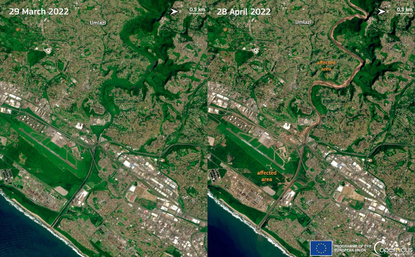
Credit: European Union, Copernicus Sentinel-2 imagery.
Introduction to the course
Flooding is one of the most frequent and devastating natural hazards affecting African countries, with significant impacts on infrastructure, agriculture, livelihoods, and ecosystems. The increasing availability of Earth Observation (EO) data and cloud-based processing platforms provides unprecedented opportunities to monitor, forecast, and analyse flood events at multiple spatial and temporal scales across the continent.
This online course will provide participants with practical knowledge and hands-on experience in the use of satellite EO data and operational services for flood monitoring in Africa. The course will cover key components of the flood management chain, including its use in early warning systems, flood mapping using Sentinel‑1 and Sentinel‑2 data, and the integration of auxiliary datasets such as rainfall, soil moisture, and topography among others.
Participants will work with African case studies and datasets, using cloud-based platforms. The participants will also be introduced in an online flood hydraulic model (Fast Flood) allowing fast evaluation of floods for own selected areas.
The training is strongly oriented towards independent learning and practical implementation, allowing participants to develop reproducible workflows for flood monitoring applications.
This course will provide participants with the ability to:
- Understand the principles of flood forecasting and early warning systems in the African context.
- Access, interpret, and compare outputs from some choice of global and regional systems such as GLOFAS, CEMS, GEOGLOWS, and SERVIR Africa.
- Retrieve and process Sentinel 1 SAR data to derive flood extent maps under all weather conditions.
- Use Sentinel 2 optical imagery to compute water indices and analyse flood dynamics.
- Combine SAR and optical data to improve flood detection accuracy.
- Integrate rainfall, soil moisture, and topographic datasets into flood analysis.
- Interpret the drivers and impacts of flood events using multi-source EO datasets.
- Evaluate the advantages and limitations of different EO data sources and methods for flood monitoring.
- Experience the hydraulic model Fast Flood for online flood hazard assessment.
Mode of Delivery
The course consists of videos, PowerPoints, quizzes, and practical exercises, supplemented by reading material and reference materials. All materials will be offered through the Moodle Cloud learning platform.
Participants are expected to digest the training materials independently (i.e., no live teaching is foreseen). Interaction with the teaching staff will be possible through a series of dedicated live feedback sessions (hosted through MS Teams) and a Q&A forum.
Prerequisites
Knowledge of Earth Observation principles and basic image processing techniques including Python programming language would be an asset, but it’s not a must.
Selection
The course will be offered to a maximum of 75 participants. Selection will be based on relevant academic background and employment. Only applicants working for an African-based organization are eligible. We will strive to have a gender-balanced and country-balanced group of participants. Preference is given to candidates working as (Ph.D.-) researchers, post-doc, and university staff. Selection will be made two weeks before the course starts. Participants are expected to notify their employer or institution about commitment to this online course.
Timeline
The course runs over 4 consecutive weeks, with a total workload of maximum 10 hours per week (including theory, self-study, practical exercises, and quizzes).
- Week 1 – Flood Forecasting and Early Warning:
Exploration of operational systems such as GLOFAS, CEMS, GEOGLOWS, SERVIR Africa, and rainfall-based early warning services, with African case studies.
- Week 2 – Flood Modelling:
Module (FASTFLOOD) on flood modelling concepts and applications.
- Week 3 –Flood Mapping using EO:
Hands-on generation of flood extent maps using Sentinel 1 (SAR), Sentinel 2 (optical), and combined approaches.
- Week 4 – Supporting EO Data for Flood Hydrology:
Use of auxiliary datasets including DEMs, satellite altimetry, rainfall, soil moisture, and soil properties for understanding flood processes.
Each week includes:
- ~2 hours of theoretical material
- ~2 hours of guided/self-study
- ~3.5 hours of hands-on practical exercises
- ~30 minutes of automated quizzes for assessment
- 1 hour of Q&A
Additionally, five live sessions (60 min each) with teachers will be organised on:
- Monday, September 14, 10:00 AM – Live introduction to the course
- Monday, September 21, 10:00 AM – Live introduction to Fastflood
- Friday, September 18, 15:00 PM
- Friday, September 25, 15:00 PM
- Friday, October 2, 15:00 PM
- Friday, October 9, 15:00 PM
- Friday, October 16, 15:00 PM – Closing
(All CEST-times which is UTC +2)
Certificate of completion
Participants will complete practical workflows and demonstrate their understanding through quizzes based on the exercises. Based on a positive score of the quizzes a certificate of Completion will be provided.
Teachers
-

Hydrologist – Earth Observation Senior Lecturer – Department of Water Resources, Faculty ITC of the University of Twente
https://people.utwente.nl/g.n.parodi
g.n.parodi@utwente.nl -

Assistant Professor Multi-Hazards – Faculty ITC of the University of Twente
https://personen.utwente.nl/b.vandenbout
b.vandenbout@utwente.nl