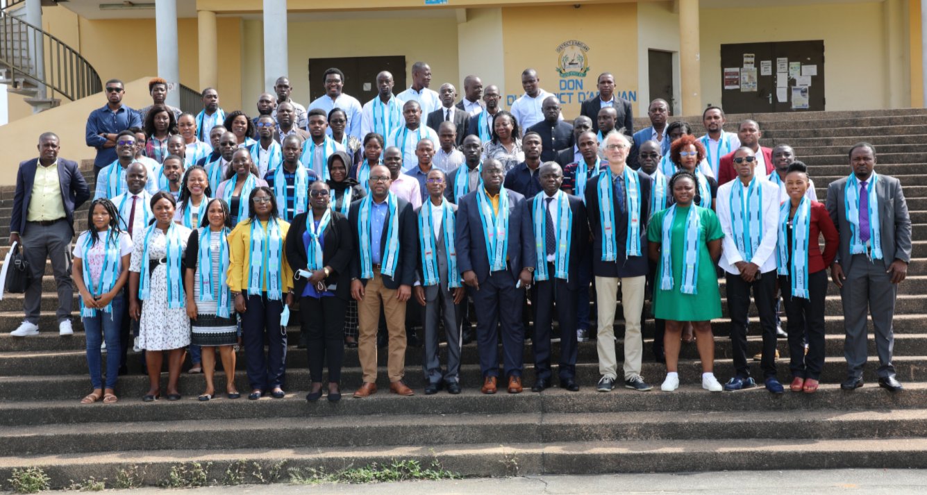
During the AfricaGIS 2021 conference held in Abidjan, Côte d’Ivoire on 22nd – 26th November 2021, 40 participants from 21 countries all over Africa came together to solve challenges related to the Food Security and Water Resources. EO Africa R&D Facility, ESA, the African Commission, GMES & Africa and CURAT are pleased to announce the winners.
The event was kicked-off by a webinar held on the 17th November during which the teams were provided with information regarding the logistics, resources, and data available during the main event. The teams were created by the organizers in order to foster collaboration between participants from diverse backgrounds and based on their expertise and research interests and had several days to meet and discuss their projects on a dedicated chat platform before travelling to Abidjan. During the 3-day long main hackathon event, coders, scientists, students and entrepreneurs and space enthusiasts worked together to address challenges related to:
- Freshwater resources dynamics and water scarcity
- Coastal monitoring (water quality, coastal changes, ship detection)
- Impact of COVID-19 pandemic on agricultural production
- Conflict and food security – linking decrease in agricultural production to armed conflicts
using the EO Africa R&D Facility Innovation Lab, an interactive cloud processing platform that combines a wealth processing tools and data from Earth-observing satellites as well as complimentary datasets.
The winners of the Africa GIS 2021 Hackathon were chosen as their projects best demonstrated the use of open science principles, feasibility, and innovation in solving the above challenges.
1st place
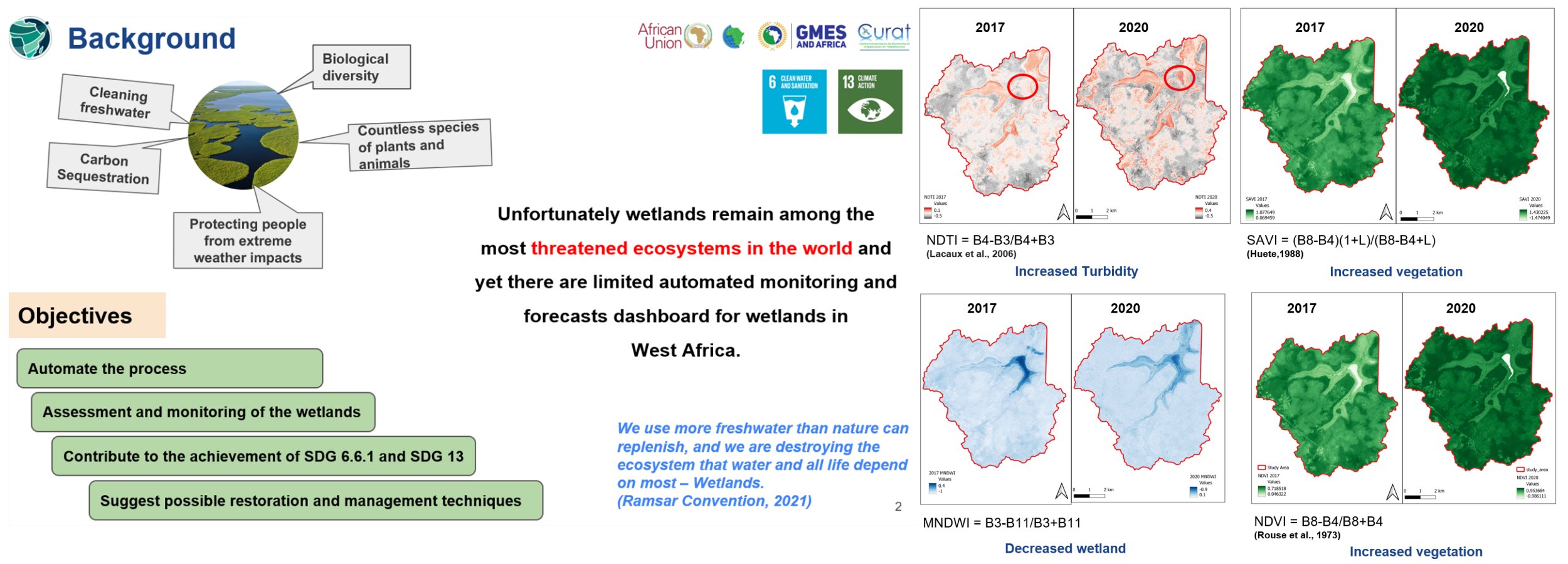
Automating wetlands assessment and monitoring using EO data and cloud technology
Ibrahim Salifou Toure (Côte d’Ivoire), Elisée Tchana (Cameroon), Emmanuel Jolaiya (Nigeria), Caroline Edinam Doe (Ghana)
Wetlands are a hotspot of biological diversity and provide the water and primary productivity on which human, animal and plant life depends. Over the last three decades, wetlands, especially those found in West Africa, have undergone drastic decline due to climate change and anthropogenic activities. This suggests the urgent need to establish an adequate strategy for the monitoring and sustainable management of wetlands in West Africa. Within this framework, we propose the studying and monitoring of wetlands leveraging Earth Observation (EO) dataset and cloud technology.
The aim of this project is to automate the monitoring and assessment of the Lagoa De Cufada wetland in Guinea-Bissau, where the watershed has experienced some decrease to the benefit of agricultural activities, in order to facilitate rapid decision making. Using the Innovation Lab platform from EO AFRICA R&D Facility, we programmatically accessed Sentinel-2A Cloud Optimized GeoTiffs (COGs) imagery for the years 2017 and 2020 covering the study area to perform band ratioing analyses such as the Normalized Difference Water Index (NDWI), Normalized Difference Vegetation Index (NDVI), Normalized Difference Turbidity Index (NDTI), and Soil Adjusted Vegetation Index (SAVI) to access the rate of wetland degradation. The results showed a progressive decrease in wetland size and water quality. This suggests the need for urgent sustainable action on the wetland ecosystem to prevent its extinction.
2nd place
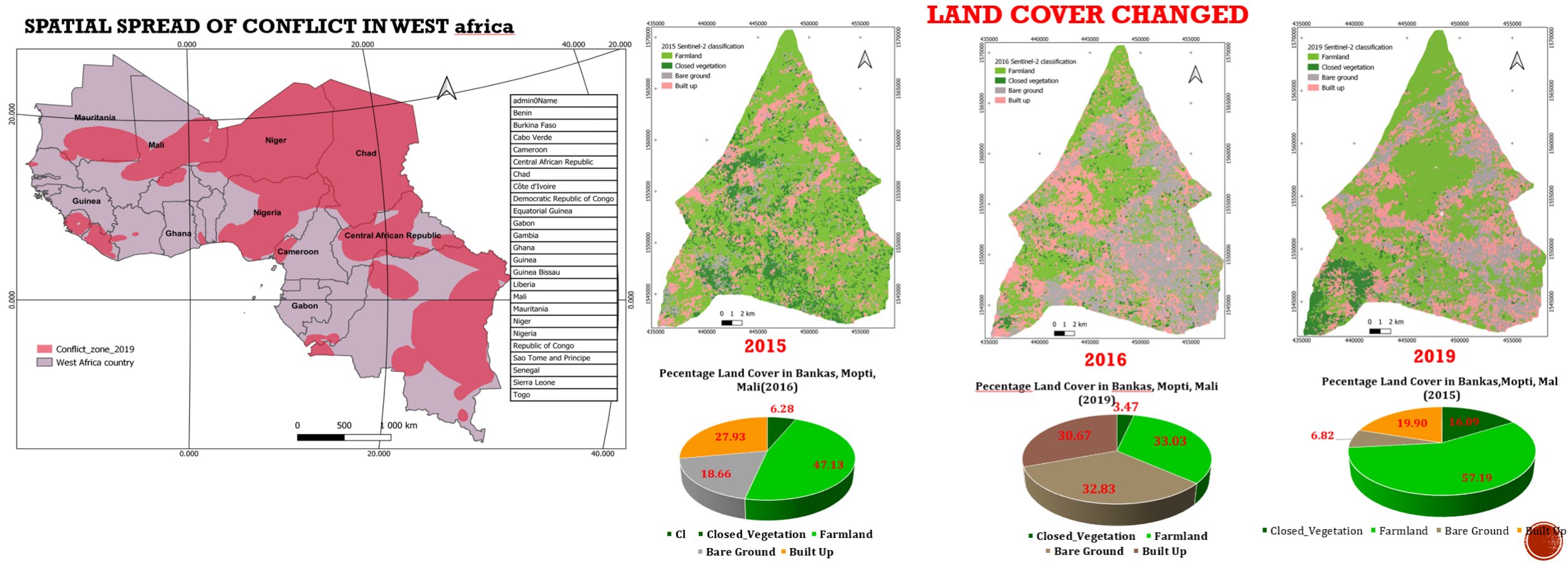
Estimation of conflict-induced decrease in agriculture production using sentinel 2 imagery in Mali – an object-based approach
Jesse Buyungo (Uganda), Amandine Carine Njeugeut Mbiafeu (Côte d’Ivoire), Lassine Sanankoua (Mali), Jagila Jantiku (Nigeria)
Renowned scholars, intellectuals and world leaders have in recent times come to unanimously agreed that we are in difficult times, and that the world is currently challenging more than it has ever been since the second world war. The advent of the COVID-19 virus amidst several other pandemics ranging from terrorism and banditry, population increase beyond control to climate change has further crippled the productivity of many countries around the world. Consequently, the threat to food security which is the biggest hazard to humanity has intensified. Sadly, this situation has not been prioritized and is not treated with the urgency it requires. Lot of issues surrounding food supply have increased in recent years due to population increase, high demands and low production, methods of farming, supply chain management and conflict amongst others.
This study examined and established the impact of conflict on agricultural production in the Bankass community of Mopti region in Mali. The community was purposely selected due the high rate of conflict that have heavily impacted the livelihood of its people, hence food security. Some of the problems this study attempts to address are the untold hardship and difficulty faced by the displaced people of Bankass communities due to conflict, the food insecurity hazards posed by these conflicts to Malians, their neighboring countries, and the threat this poses to the implementation and attainment of the Sustainable Development Goals.
An Object Based Approach procedure on Sentinel-2 Imagery of Bankass between the years 2015- 2019 was employed, respondents were randomly sampled from two different communities in Bankass where conflicts have occurred over time. Imagery was classified to establish conflict induced farmland loss and production decrease. The work also computed the Land cover area in each classified image and determine the land cover change matrix over the chosen period (2015, 2016 and 2019) and then proposed a web map application for monitoring agricultural production in the conflict areas. Lastly, we suggested a possible solution for managing the any associated risk using a community participatory GIS technique for conflict resolution.
3rd place
Monitoring Food Insecurity and Vulnerability using Earth observation Data
Rejoice Ini Eshiet (Nigeria), Tinebeb Yohannes (Ethiopia), Yves Beugre Kossou (Cote d’ivoire), Abdou Babaye (Niger)
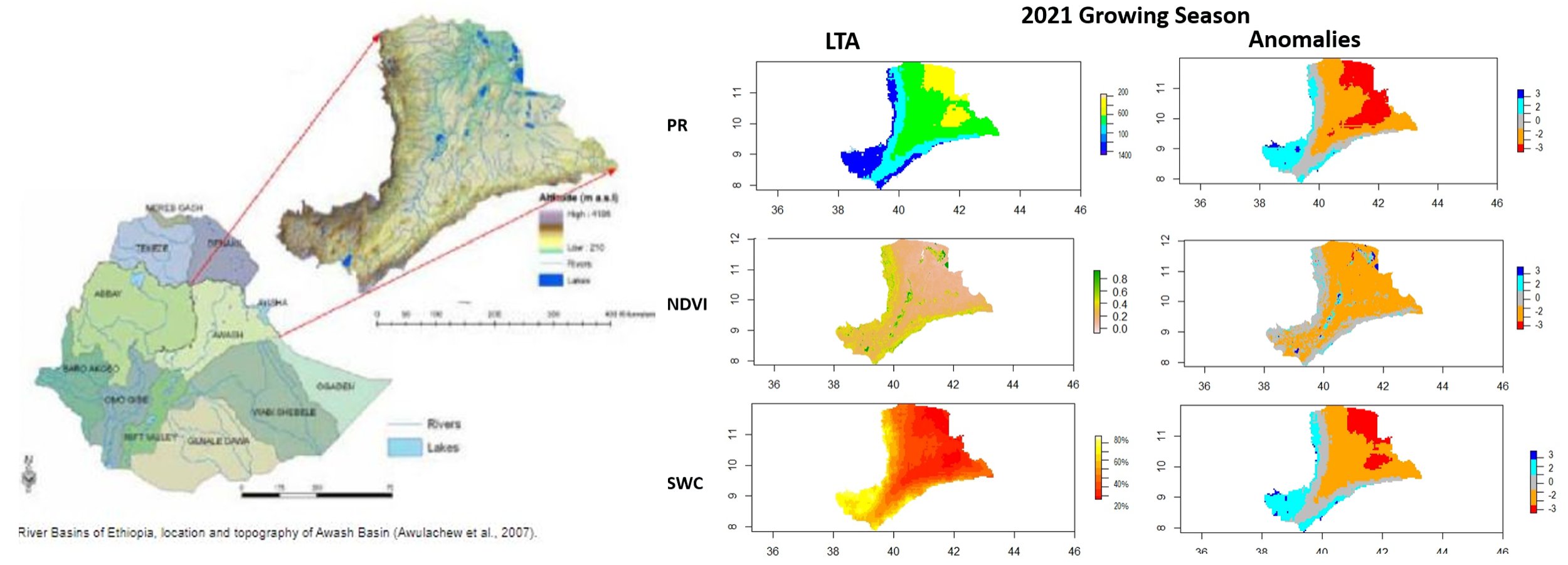
Ethiopia faces high levels of food insecurity and vulnerability, ranking as one of the hungriest countries in the world, with an estimated 5.2 million people needing food assistance every year. The Awash basin is one of the main wet basin and agricultural growth corridors of Ethiopia and it is characterized by recurring food insecurity. This cyclical situation is becoming more and more structural due to the periodic effects of drought and flood. In this basin, agriculture occupies 85% of the population and during the last decades, the increased decline in agricultural yield affects family incomes, resulting in poverty and famine. Despite there are yearly basis of food assistance in the basin there is inadequate information to access food insecurity and vulnerability in real time.
This study aimed to develop real time assessment for monitoring and vulnerability of food insecurity using earth observation data. We used EO Africa R & D Facility Innovation Lab and open-source remote sensing data. We used 1) Precipitation (pr), 2) Normalized Difference Vegetation Index (NDVI) and 3) Soil Water (Moisture) Content (SMC) for the basin from 2000 – 2020 as historical period and assessed a baseline year 2020/21 for main growing season of June, July, and August (JJA) using Long Term Average (LTA) and anomalies of the three variables.
The total area identified with rainfed agriculture for the Awash basin is 920,717 ha in 2020/21 growing season. In the eastern side, the basin faces water shortages, as precipitation drops by 20% from the average. Meanwhile the change in SMC and NDVI as a consequence of water scarcity shows 30% and 25 % drop respectively. Hence, the result indicates that Earth observation data brought enough information on agricultural monitoring systems and be able to support the food insecurity assessment activities.