10 new tandem research projects funded by ESA’s EO AFRICA R&D Facility
ESA’s EO AFRICA Research and Development Facility is proud to announce 10 new research projects to be conducted by African-European tandems. Out of the 143 proposals which were submitted in the 4th call for proposals, !0 projects have been selected. Each project will run for 15 months starting from September 2025. The selected research projects cover various topics which leverage Earth Observation data sources related to atmospheric pollution, droughts, water level monitoring, to crops, biomass and carbon stocks.
Earth Observation for African Research Challenges
Following the successful first three rounds of calls for research proposals, the EO AFRICA R&D Facility, in coordination with the European Space Agency (ESA) and the African Union Commission (AUC), launched in Apr 2025 a 4th call for proposals. The aim of this call is to extend the support to African-European collaborative research efforts in the domain of EO applications. Similar to the previous calls, applicants were invited to submit their research ideas to create EO-based algorithms and workflows by leveraging cutting-edge cloud-based data access and computing infrastructure to tackle water and food security challenges in Africa.
Fostering African European research collaboration
This grant provides the selected proposals with 30,000 EUR for research activities during a period of 15 months. In addition, awarded projects will get free access to cloud-based Virtual Research Environments through the Innovation Lab of the Facility, dedicated user and technical support, access to EO AFRICA Space Academy events, and integration into the EO AFRICA Network for international scientific collaboration.
The 143 submitted proposals were evaluated by the Selection Committee in collaboration with ESA and AUC, resulting in 10 research tandem projects (listed below). The contractual arrangements with the associated institutes are expected to be finalized soon.
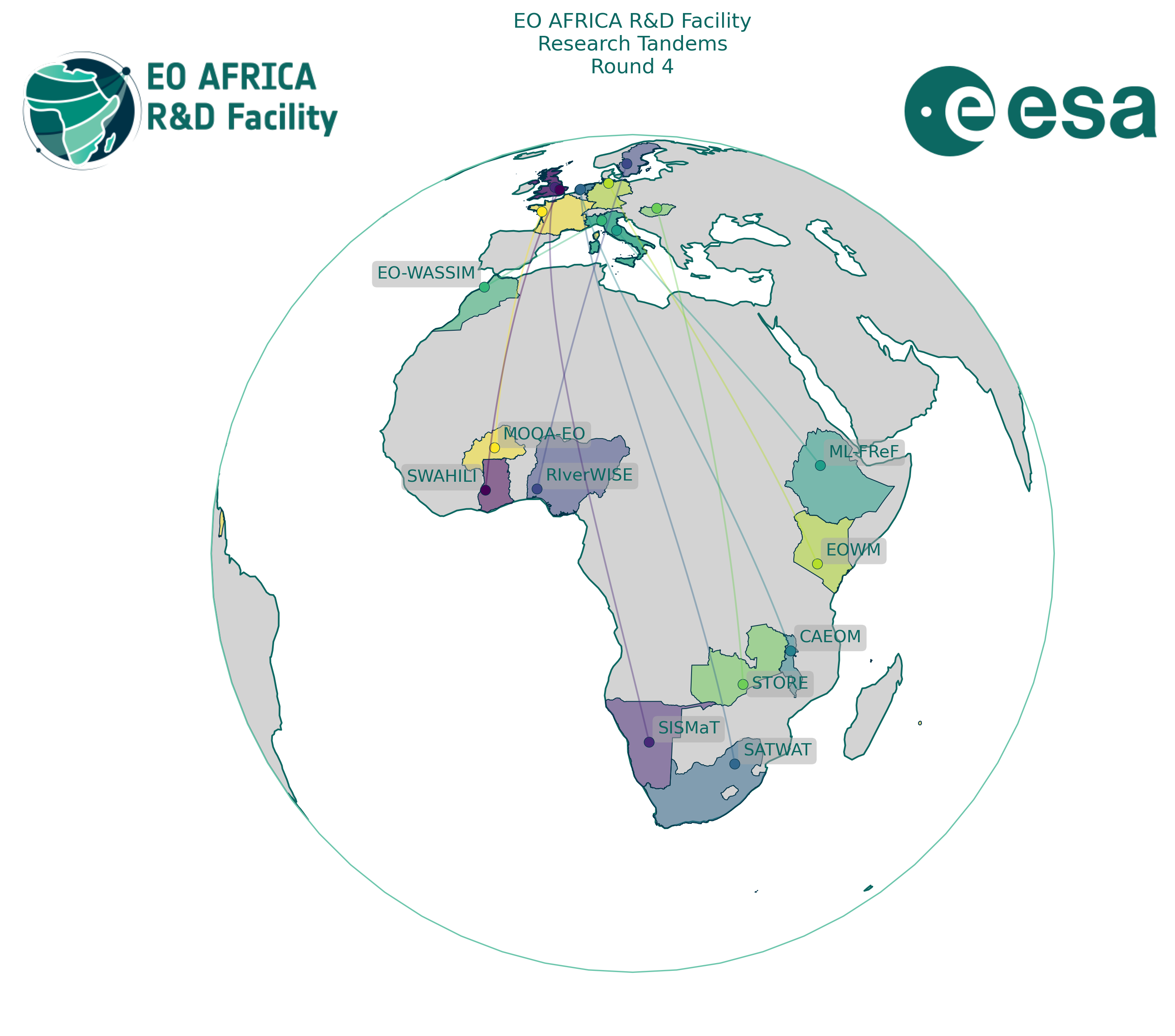
| Title | Countries | Co-Pi’s | |
|---|---|---|---|
| 1. | Satellite-based Water Assessment for Holistic Integrated Lake Information. (SWAHILI_GH_GB) |
Ghana United Kingdom |
Siabi, Ebenezer Kwadwo Borgomeo, Edoardo |
| 2. | Enhancing Land Degradation Neutrality reporting in Kenya through EO-based woody weeds monitoring. (EOWM_KE_DE) |
Kenya Germany |
Agboka, Komi Mensah Dubovyk, Olena |
| 3. | Smart Irrigation Scheduling and Yield Forecasting for Maize in Namibia’s Maize Triangle Using Earth Observation. (SISMaT_NA_GB) |
Namibia United Kingdom |
Ajayi, Oluibukun Kuta, Abdullahi |
| 4. | Water Yield Estimation and Irrigation Demand Modelling using Multi-Sensor Earth Observation Data within a Tropical River Basin. (RIverWISE_NG_SE) |
Nigeria Sweden |
Fashae, Olutoyin A. Akinyemi, Felicia O. |
| 5. | Machine-Learning-driven Flood Resilience Framework in Ethiopian Lake-Watersheds. (ML-FReF_ET_IT) |
Ethiopia Italy |
Abebe, Sintayehu Gariano, Stefano |
| 6. | WAter and Salinity Stress IMpact on crop yield due to unconventional water use for irrigation employing satellite data and agro-hydrological modelling. (EO-WASSIM_MA_IT) |
Morocco Italy |
Ouakil, Abdelhadi Paciolla, Nicola |
| 7. | Space-based impact assessment of invasive alien trees on evapotranspiration and water security in southern Africa. (SATWAT_ZA_NL) |
South Africa Netherlands |
Rebelo, Alanna Van Cleemput, Elisa |
| 8. | Cloud-Based and AI-Enhanced Earth Observation for Mapping and Forecasting Hydrological Extremes and Irrigation Demand in selected catchments in Malawi. (CAEOM_MW_NL) |
Malawi The Netherlands |
Chunga, Brighton Karthikeyan, Brindha |
| 9. | Unlocking the Potential of the Ungauged Small Reservoirs to Mitigate Water Scarcity and Enhance Food Security. (STORE_ZM_HU) |
Zambia Hungary |
Banda, Kawawa Vekerdy, Zoltán |
| 10. | Monitoring and modelling the microbiological quality of current and future surface waters in West Africa using Earth observation data. (MOQA-EO_BF_FR) |
Burkina Faso France |
NIKIEMA, D. Edwige Robert, Elodie |
1Satellite-based Water Assessment for Holistic Integrated Lake Information (SWAHILI_GH_GB)
Lakes play a vital role in Africa’s water and food security, providing drinking water, supporting agriculture, and sustaining local economies. However, many African lakes are shrinking or facing pollution due to climate change and growing human activities. Monitoring these changes is difficult because traditional field surveys are costly and cloud cover can limit the usefulness of optical satellite images.
The SWAHILI project brings together researchers from UK and Ghana to create an open-source tool that combines multi-modal satellite data for holistic lake monitoring. Using advanced machine learning, our workflow will map surface-water extent, water quality, and water levels for lakes, in any season. This approach overcomes the existing challenges of cloud cover and can be used for both local and transboundary lakes.
All results, code, and training materials will be shared openly through interactive Notebooks, making them accessible for local users, scientists, and policymakers across Africa. SWAHILI will be tested on diverse case studies, including Lake Bosomtwe (Ghana) and Lake Victoria (Tanzania, Kenya, Uganda), to ensure the method is robust and transferable. The project is expected to improve our ability to provide better, timely information to help safeguard Africa’s vital lakes crucial for water and food security.
2Enhancing Land Degradation Neutrality reporting in Kenya through EO-based woody weeds monitoring (EOWM_KE_DE)
Invasive woody weeds such as Prosopis juliflora are increasingly degrading rangelands and devastating community livelihoods in eastern Africa, especially in Kenya. The shrub suppresses biodiversity, reduces fodder availability, blocks livestock access to water points, and exacerbates drought conditions. Despite these severe impacts, invasive species like Prosopis are often overlooked in Land Degradation Neutrality (LDN) reporting, which relies heavily on EO-based vegetation productivity trends. However, due to its evergreen nature and rapid growth, Prosopis can produce misleading “positive” trends, masking actual ecological degradation.
This project will develop and test an EO-based monitoring routine using satellite data in southern Kenya (Nguruman), a region severely affected by invasion. We will combine time-series spectral and phenological analyses to distinguish Prosopis from co-occurring vegetation, using existing ground-truth data from an ongoing animal health project.
Results will be validated and integrated into a refined LDN reporting framework in collaboration with Kenya’s national focal points.
The project will also engage local communities and policy stakeholders to support uptake. An interactive GIS web portal will visualize invasion dynamics and promote outreach. By addressing a critical methodological gap in current LDN frameworks, this project will improve reporting accuracy and guide more effective land restoration planning.
3Smart Irrigation Scheduling and Yield Forecasting for Maize in Namibia’s Maize Triangle Using Earth Observation (SISMaT_NA_GB)
This project will develop an Earth‐Observation (EO)-based decision‐support system that prioritises irrigation scheduling to help smallholder farmers in Namibia’s Maize Triangle to optimise water use, while also providing maize yield forecasts as a secondary benefit. The system will generate high‐resolution field maps of evapotranspiration, soil 2 moisture, and vegetation health that guide precise irrigation timing and amounts by integrating optical (Sentinel-2), RADAR-SAR (Sentinel-1), and thermal (Landsat and OpenET) imagery. Combining these EO‐derived metrics with local weather records will feed machine‐learning models that forecast yield outcomes weeks ahead of harvest to ensure that any irrigation-driven adjustments also support crop productivity. Farmers, extension agents, and agricultural agencies will access near‐real‐time water‐stress alerts and irrigation recommendations through Jupyter Notebooks hosted on GitHub and deployed via the EO AFRICA Innovation Lab’s cloud‐based environment. Field validation in Oshikoto and Otjozondjupa regions will verify that satellite‐derived evapotranspiration and soil moisture match ground measurements within error margins suitable for operational decisions. This tool aims to significantly reduce water use while maintaining maize yields by focusing on irrigation scheduling, which directly contributes to Namibia’s water and food security goals in response to United Nations Sustainable Development Goals 2 and 6.
4Water Yield Estimation and Irrigation Demand Modelling using Multi-Sensor Earth Observation Data within a Tropical River Basin (RIverWISE_NG_SE)
The unpredictable nature of rainfall due to climate change in Southwestern Nigeria (SWN) has limited agricultural productivity despite abundant rivers. Rainfed smallholder farming systems dominate in SWN as irrigation use remains limited. Aimed to provide scientific input for harnessing irrigation, the RiverWISE project will improve water management strategies to enhance agriculture in the Ogun-Osun River Basin, one of Nigeria’s 11 basins. This study will rely on multi-sensor Earth Observation (EO) data to improve the poor state of data availability. The hydrological models, SWAT and HEC-HMS, will be used to evaluate drainage patterns, landform dynamics, land cover, and soil-water interactions, as well as their “influence on yield and irrigation demand in the basin. Irrigation demand for maise, a major crop in SWN, will be simulated under different drought scenarios using the open-source AquaCrop-OSPy for crop-water modelling. RiverWISE’s EO-based workflow, integrating remote sensing and local datasets (e.g., rainfall, crop yield) in the hydrogeomorphological and crop-water models, will support irrigation management practices for climate-resilient smallholder agriculture in similar tropical basins. Local capacity building includes stakeholders’ workshop for farmers, extension workers, and water managers on optimising water use, increasing crop yields, and adapting to climate variability and change. Also, training aimed at researchers will be conducted to support the adoption and use of open-source tools for sustainable irrigation water use. RiverWISE will support the goals of EO AFRICA in strengthening African-led Earth Observation expertise by addressing persistent water and food security challenges.
5Machine-Learning-driven Flood Resilience Framework in Ethiopian Lake-Watersheds (ML-FReF_ET_IT)
Floods pose significant challenges to communities in the Lake watersheds of Ethiopia, affecting livelihoods, infrastructure, and food security. The situation is worsened by the lack of comprehensive information on flood susceptibility and management strategies, combined with increasing pressures from climate change and land-use changes. Therefore, this project aims to develop an innovative flood susceptibility mapping framework by integrating Earth Observation (EO) data with advanced machine learning techniques. Using datasets from the European Space Agency (ESA) and other EO missions, we will analyze environmental variables—such as precipitation patterns, topography, and land use—to create predictive models for flood-prone areas. Our approach will leverage cloud-based processing platforms to ensure efficient data analysis and accessibility. The project’s outcomes will support disaster risk reduction efforts and provide actionable insights for policymakers and humanitarian organizations. By fostering collaboration between African and European researchers, we aim to enhance climate resilience strategies and promote EO-driven solutions for sustainable environmental management across Africa.
6WAter and Salinity Stress IMpact on crop yield due to unconventional water use for irrigation employing satellite data and agro-hydrological modelling (EO-WASSIM_MA_IT)
This project proposes the synergic use of satellite data and agro-hydrological modelling to quantify crop yield and the contributions of green, blue and grey water to its development. The effects of water scarcity and unconventional water use for irrigation (saline or reused water) on different local crops will be investigated, in order to monitor and forecast yield in water-scarce and salinity-affected areas in Morocco.
High-spatial resolution EO data from multiple sensors (e.g., land surface temperature (LST) from Sentinel 2 3, soil moisture (SM) from Sentinel-1 and vegetation indices from Sentinel-2) will be assimilated into agro-hydrological models (FEST-EWB-SAFY and SEBAL, implemented in SCO-IRRISAT) to quantify the combined effect of crop stressors on yield, in order to support farmers in precision agriculture as an adaptation strategy to climate change. The project will focus on the entire Doukkala irrigated district, in central Morocco, which has been suffering for the last 5 years from a prolonged drought and the use of unconventional water for irrigation is a measure to contrast water scarcity. This project relies on previous projects experience of the research team. The final workflow will be developed as an open-source Jupyter Notebook to maximize its diffusion across the involved scientific and lay communities.
7Space-based impact assessment of invasive alien trees on evapotranspiration and water security in southern Africa (SATWAT_ZA_NL)
Invasive alien trees threaten water security across southern Africa by increasing evapotranspiration (ET) and reducing streamflow and groundwater recharge. This reduces resilience in the face of anthropogenic climate change and urgent interventions are required. However, given limited funds, which invasions should be prioritised for clearing? One way to prioritize is by quantifying water-related impacts. SATWAT will estimate the effect of different invasive taxa (e.g., pines, gums, wattles) on ET in different biomes across southern Africa. The project will use Sentinel-2 imagery to map invasions and quantify their direct impacts on ET by controlling for confounders such as altitude, aspect, rainfall, temperature and soils.
Exploring ET across large spatial scales with varying environmental conditions is challenging because these conditions themselves may also affect ET. Earth Observation (EO) data will be integrated with causal inference statistics to tackle this challenge. Ultimately, SATWAT aims to provide a user-friendly open-access tool to simulate the effect of invasion on ET for various scenarios. This evidence-based tool will be demonstrated and discussed during a stakeholder workshop, and may support land and water managers in prioritizing and motivating funding of restoration efforts. The project will demonstrate how EO data, combined with advanced causal modelling, can inform nature-based solutions and strengthen regional water security.
8Cloud-Based and AI-Enhanced Earth Observation for Mapping and Forecasting Hydrological Extremes and Irrigation Demand in selected catchments in Malawi (CAEOM_MW_NL)
Malawi is increasingly affected by climate-induced disasters such as floods and droughts, threatening food and water security. In response to this, this project proposes a cloud-based solution that combines satellite Earth Observation (EO) data and Artificial Intelligence (AI) to improve the prediction of hydrological extremes and estimate irrigation demands across the country. Using high-resolution imagery and DEM from Sentinel and Landsat missions, as well as FAO’s soil data, coupled with ground-based calibration and validation meteorological, soil and crop data, the research will develop open-source Long Short-Term Memory (LSTM) networks and Random Forest machine learning models that forecast and map flood and drought risks in real time. Outputs will include a cloud-hosted dashboard accessible to government agencies, farmers and NGOs, helping them make informed decisions on water management and agricultural planning. The project will be validated in partnership with national institutions such as Malawi’s Department of Climate Change and Meteorological Services (DCCMS) and scaled through training workshops and stakeholder engagement. By bridging the gap between climate data and practical decision-making, this project directly supports Africa’s resilience to climate change and aligns with the ESA EO AFRICA R&D Facility’s goal of advancing operational EO solutions for water and food security.
9Unlocking the Potential of the Ungauged Small Reservoirs to Mitigate Water Scarcity and Enhance Food Security (STORE_ZM_HU)
The transboundary Zambezi River Basin faces rising water scarcity and climate-related challenges that threaten agriculture and livelihoods. Small, ungauged reservoirs within the basin have unknown storage capacities, thus limiting effective water management. With climate change expected to worsen water stress, sustainable water resource management is crucial for the region’s food security. Addressing the existing data gaps surrounding these reservoirs is essential to improving water allocation, enhancing climate resilience, and supporting sustainable development across the Zambezi Basin. This project aims to systematically map ungauged small reservoirs, analyse their bathymetry and sedimentation to estimate water storage capacities, and aggregate data to assess regional water storage potential. An interactive prototype decision support dashboard will integrate real-time reservoir data to provide a comprehensive view of the water resources. It will support water management to satisfy agricultural water demand and climate risk assessments. Underlying methods include remote sensing, field surveys, GIS analysis, and machine learning-based modelling. Expected results include a map showing the spatial distribution of small ungauged reservoirs, their water storage capacity estimates. A prototype dashboard will include the developed workflow. The project’s outputs will support policymakers and water managers in optimising small ungauged reservoir use for enhanced sustainable water management and food security.
10Monitoring and modelling the microbiological quality of current and future surface waters in West Africa using Earth observation data (MOQA-EO_BF_FR)
Diarrheal diseases in tropical areas were responsible for 1.17 million deaths in 2021 (Kyu et al. 2024), including 518,367 in Africa (WHO, 2024). The high prevalence observed in sub-Saharan Africa, particularly in rural areas, is linked to significant contamination of surface water. To assess water contamination and the associated risk of diarrheal diseases, the WHO recommends the use of Escherichia coli (E. coli), which is considered as the best indicator of fecal contamination (Edberg et al. 2000; Kay et al. 2004).
Furthermore, suspended particulate matter (SPM) can contribute to the survival and growth of pathogens in water, providing protection from predators and the sun’s UV rays (Rochelle-Newall et al. 2016; Petersen et al. 2020). In a context where in situ data are scarce, tele-epidemiology appears to be a powerful tool for studying the climate-environment-health relationship and for understanding and predicting the spatio-temporal distribution of pathogens through the use of Earth observation (EO) data. The first objective is to validate the SPM inversion algorithms in tropical areas. The second objective of MOQA-EO is therefore to design environmental monitoring methods using EO data to monitor health hazards (E. coli and SPM concentration in surface water) in a context of climate changes.