This component of the Space Academy includes a series of webinars covering topics related to the use of EO to assess and monitor the state of water and food security-related spatial components. Each Webinar consists of three sections: theoretical background, applications examples a Q&A session.
The selected topics for the webinars include:
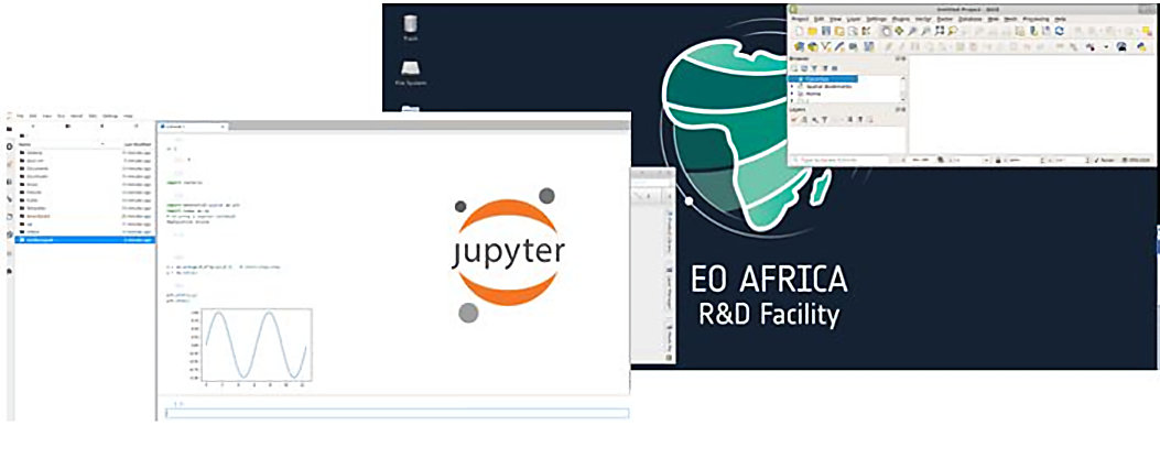
1st on the EO AFRICA R&D Facility Webinar Series
Introduction to Cloud Computing for EO Analyses
This webinar introduces Cloud Computing and its usage to analyse and process Earth Observation (EO) data. It also explains the topic of interactive computing through Jupyter Notebooks and JupyterLab as one of the technologies that have been used over Cloud Computing platforms for developing analytical procedures accompanied with narrative text, equations, images, and analysis outputs.
The duration of the webinar is 1 hour. During the webinar there is a live-chat available.
Basic python scripting is appreciated but not essential.
Webinar is executed under the framework of the EO AFRICA R&D by the University of Twente – Faculty of Geoinformation Science and Earth Observation.
Speakers:
-
Assistant Professor – Department of Geo-information Processing, Faculty ITC of the University of Twente
https://people.utwente.nl/m.farnaghi
m.farnaghi@utwente.nl -
Assistant Professor – Department of Geo-information Processing, Faculty ITC of the University of Twente
https://people.utwente.nl/m.khodadadzadeh
m.khodadadzadeh@utwente.nl -
Assistant Professor – Head of the Center of Expertise in Big Geodata Science (CRIB) – Faculty ITC of the University of Twente
https://people.utwente.nl/s.girgin
s.girgin@utwente.nl
Downloads and recordings:
The Jupyter notebook for the demo can be downloaded here.
You can find the recording of the webinar in our YouTube Channel or you can watch it here:
2nd on the EO AFRICA R&D Facility Webinar Series
Access to Earth Observation
The webinar aims to present which Earth Observation datasets are accessible via Data and Information Access Services (DIAS) platforms, and demonstrate how such imagery can be queried, selected and downloaded. For this purpose, a direct-download solution from a data provider will be demonstrated, followed by a free open-source solution (EODAG), and related python libraries.
The duration of the webinar is 1.5 hours. During the webinar there will be a live-chat available.
Participant should be acquainted with remote sensing data and basic python scripting.
The webinar will be executed under the framework of the EO AFRICA R&D by CS GROUP France.
Speakers:

Downloads and recordings:
You can find the recording of the webinar in our YouTube Channel or you can watch it here:
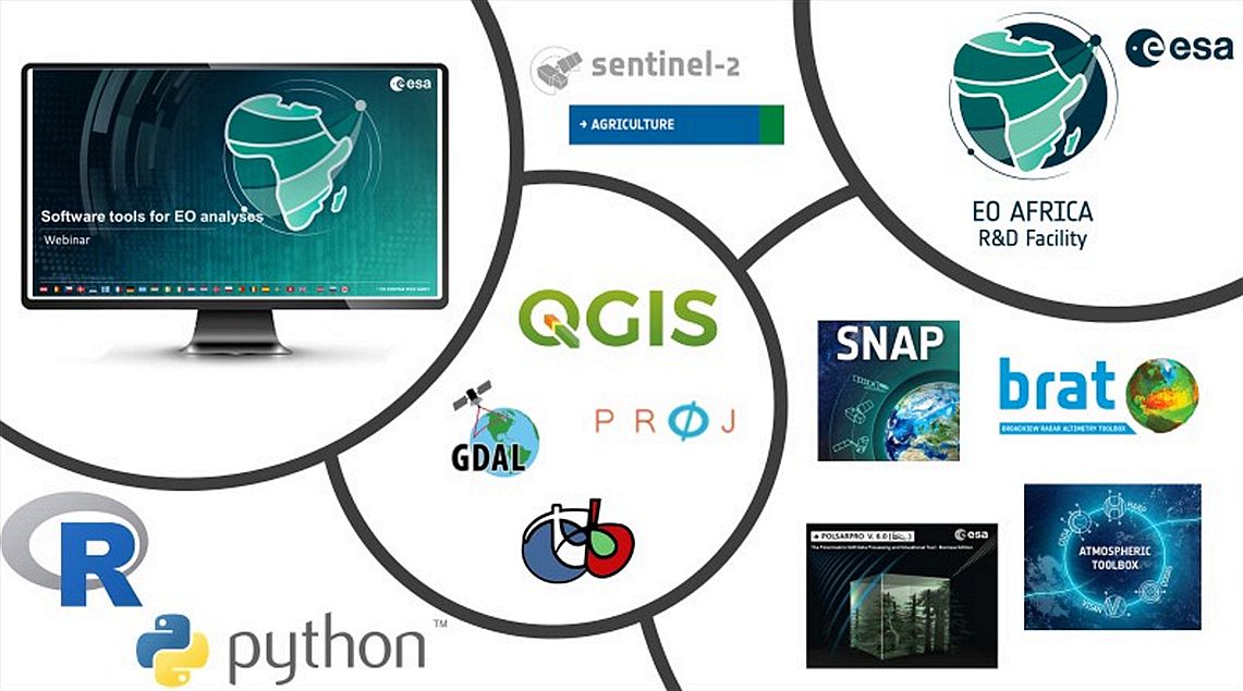
3rd on the EO AFRICA R&D Facility Webinar Series
Software Tools for Earth Observation analyses
This webinar provides an overview of existing open-source tools for processing data coming from different satellite missions with a main focus on Copernicus missions’ products. During the webinar participants get familiar with ESA SNAP software and its toolboxes. Then a short demonstration of QGIS plugins used in Earth Observation is provided. Moreover, Sen2Agri system applicable especially in agriculture monitoring using both Sentinel-2 and Landsat 8 data is introduced as well. For those who prefer working in Python or R, the selection of plugins, specific for Earth Observation and image processing is demonstrated.
The duration of the webinar is 1 hour. During the webinar there is a live-chat available.
Knowledge of different data used in Earth Observation would be an asset, but is not a must.
The webinar will be executed under the framework of the EO AFRICA R&D Facility by the University of Twente – Faculty of Geoinformation Science and Earth Observation.
Speakers:
Downloads and recordings:
You can find the recording of the webinar in our YouTube Channel or you can watch it here:
4th on the EO AFRICA R&D Facility Webinar Series
Evapotranspiration from space
This webinar is devoted to evapotranspiration (ET) monitoring with Earth Observation (EO) satellites.
The webinar is going to have four parts:
-
During the first 20 minutes, the concept of ET and the Food and Agriculture Organization (FAO) Penman (1948) – Monteith (1965) approach to its modelling will be explained.
-
Then in 10 minutes the demonstration of a large scale FAO ET dataset WaPOR https://wapor.apps.fao.org/home/WAPOR_2/1 will take place.
-
In the last 30 minutes, a local scale Two-Source Energy Balance (TSEB, Norman, Kustas and Humes, 1995) model will be explained followed by its Sentinel Application Platform (SNAP) plugin realization (Sen-ET) demonstration. The sharpening of Sentinel-3 1 km Land Surface Temperature (LST) to Sentinel-2 20 m resolution is the key feature of the approach.
-
If time permits an ESA’s Third Party Missions Programme Landsat-based approach will be demonstrated.
Questions in between the sections and at the end of the webinar are most welcome.
The duration of the webinar is 1 hour. During the webinar, there is a live chat available.
Required: For participants who would like to reproduce the actions of the presenter, the registration on WaPOR FAO portal https://wapor.apps.fao.org/sign-in is needed.
Optional: For participants who would like to use the Sen-ET plugin (https://www.esa-sen4et.org/) in their research, a Windows-based ESA SNAP installation with configured Python 3.6 is needed. The setting-up issues might be tackled during the QA session. An alternative to SNAP is a Python-based version of TSEB, PyTSEB, which implies some knowledge of Python.
The webinar will be executed under the framework of the EO AFRICA R&D Facility by the University of Twente – Faculty of Geoinformation Science and Earth Observation.

Speakers:
-
Assistant Professor – Department of Water Resources, Faculty ITC of the University of Twente
https://people.utwente.nl/e.prikaziuk
e.prikaziuk@utwente.nl
Downloads and recordings:
You can find the recording of the webinar in our YouTube Channel or you can watch it here:
5th on the EO AFRICA R&D Facility Webinar Series
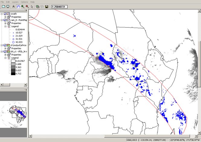
Introduction to Precipitation from Space
This webinar introduces rainfall observations obtained from satellites using the visible, thermal infrared and microwave parts of the electromagnetic spectrum and blending routines applied, using qualitative and quantitative approaches. Quantitative precipitation retrieval principles and algorithms are discussed as well as their possibilities and limitations to retrieve rainfall observations. Also, attention is given to visualization of precipitation from geostationary satellite images. A number of satellite derived rainfall products will be introduced.
During the webinar short demos are provided on how to acquire near real time rainfall products from geostationary satellites from EUMETSAT’s Web Mapping Service, use of (online) rainfall forecasts from the Global Forecasting System (GFS), perform calculations with satellite derived daily rainfall data from the SAF on Hydrology (H05B product) and rainfall retrieval from thermal infrared channel observations (from the SEVIRI instrument on MSG). These will be compared with other satellite derived rainfall products, like IMERG and H03B.
The duration of the webinar is 1 hour. During the webinar, there is a live chat available.
The webinar will be executed under the framework of the EO AFRICA R&D Facility by the University of Twente – Faculty of Geoinformation Science and Earth Observation.
Speakers:
-
Assistant Professor / Project Manager – Department of Water Resources, Faculty ITC of the University of Twente
https://people.utwente.nl/b.h.p.maathuis
b.h.p.maathuis@utwente.nl
Downloads and recordings:
You can find the recording of the webinar in our YouTube Channel or you can watch it here:
6th on the EO AFRICA R&D Facility Webinar Series
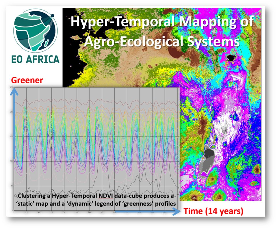
Hyper-Temporal Mapping of Agro-Ecological Systems
This webinar introduces participants with the necessary theoretical and practical knowledge to map agro-ecological systems at region to country levels (benchmark mapping) for subsequent monitoring using ‘future’ EO-derived imagery. ‘Past’ hyper-temporal (HT) time-space NDVI-based data-cubes will be studied to create an agro-environmental stratification that relates to land features like terrain, climate, land cover (green vegetation) and land use (practiced crop calendars). The data-cube also represents (seasonal) impacts of weather differences on vegetation performance and also gradual and abrupt changes in land use and land cover. Acquisition and pre-processing of the HT-vegetation (NDVI) data sets, and its visualization, interpretation and analysis will be discussed.
The duration of the webinar is 1.5 hours. During the webinar there is a live-chat available.
The webinar will be executed under the framework of the EO AFRICA R&D Facility by the University of Twente – Faculty of Geoinformation Science and Earth Observation.
Speakers:
-
Associate Professor – Department of Natural Resources, Faculty ITC of the University of Twente
https://people.utwente.nl/c.a.j.m.debie
c.a.j.m.debie@utwente.nl
Downloads and recordings:
You can find the recording of the webinar in our YouTube Channel or you can watch it here:
7th on the EO AFRICA R&D Facility Webinar Series
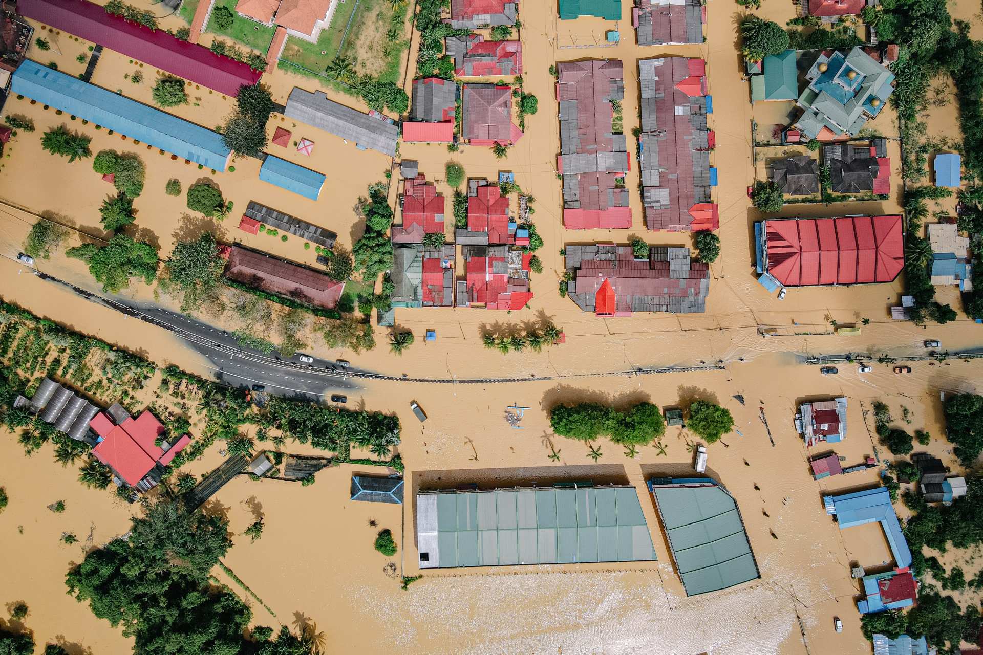
Flood Mapping with Sentinel-1 data
This webinar will focus on the importance and use of Sentinel-1 SAR data for flood mapping. With Sentinel-1 SAR data, we can map and analyse the affected flooded areas over a region, that may be not easily accessible, and even compare them with the official flood maps available.
We will also use the SNAP and QGIS software available within the Innovation Lab and have a short demonstration of the basic processing steps in order to achieve the desired result. CREODIAS will be used for the Sentinel-1 data retrieval.
The duration of the webinar is 1 hour, followed by a live Q&A session. During the webinar there is a live-chat available as well.
Knowledge of use of SAR data in Earth Observation applications would be an asset, but is not a must.
The webinar will be executed under the framework of the EO AFRICA R&D Facility by SERCO Italy S.P.A.
Speakers:
Downloads and recordings:
You can find the recording of the webinar in our YouTube Channel or you can watch it here: